As all the Indian states were locked in a battle with the COVID-19 pandemic earlier this year, an unexpected disaster struck the state of Uttarakhand on 7 February 2021—a deadly flood that left around 200 people missing or dead. A landslide was thought to be the cause of the massive flood. Now, a new study has found that the real culprit behind the disaster was not a landslide but an enormous avalanche of rock and glacier ice.
According to an international team of over 50 scientists, evidence gathered from seismic records, satellite images, and statements from eyewitnesses established that the deadly descent of ice and rock 1,800 meters across the steep slope of Ronti Peak was the origin of the events leading up to the calamity. The study was published in the journal Science.
Dr. Daniel Shugar, the corresponding author of the study, told the media: "This was a multi-hazard scenario where it was much more fluid and mobile than a landslide would be expected to be. It was a worst-case scenario of rock and ice and [the] height of the fall."
Tragic Turn of Events
![Overview of the Chamoli disaster, Uttarakhand, India--(A) 3D rendering of the local geography, with labels for main place names mentioned in the text. HPP stands for hydropower project. (B to D) Pre- and post-event satellite imagery of the site of the collapsed rock and glacier block, and the resulting scar. Note snow cover in the region just before the event (C). The red arrows in (C) mark the fracture that became the headscarp of the landslide [(22), §3.2] (fig. S4). The arrow in D points to a remaining part of the lower eastern glacier. (E) 3D rendering of the scar. (F) Schematic of failed mass of rock and ice. Satellite imagery in (A) to (D) and (E) is from Sentinel-2 (Copernicus Sentinel Data 02-10-2021) and Pléiades-HR (© CNES 02-10-2021, Distribution AIRBUS DS), respectively. Avalanche](https://data1.ibtimes.co.in/en/full/762314/avalanche.jpg?h=450&l=50&t=40)
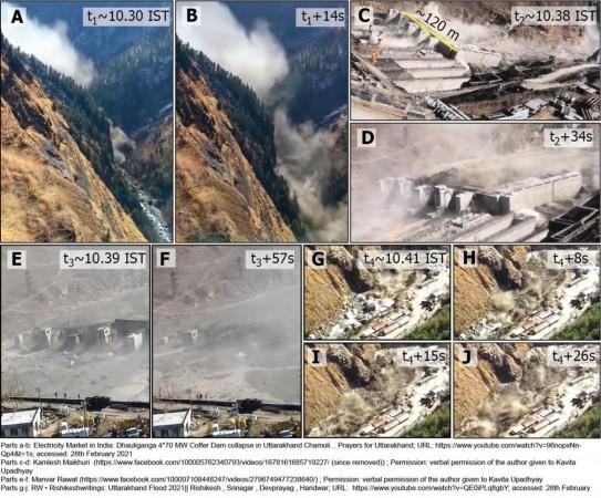
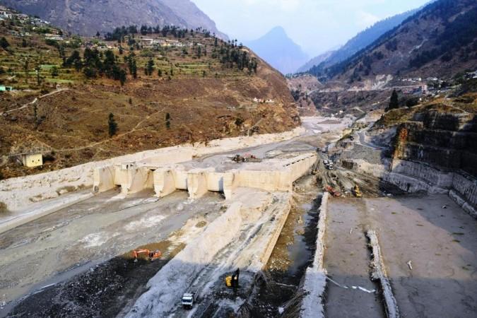
On the morning of 7 February 2021, a cataclysmic flow of mass came down the Ronti Gad, Rishiganga, and Dhauliganga valleys in the Chamoli District of Uttarakhand. The sudden flow caught the residents of the area by surprise leaving them with nowhere to run. Such was the intensity of the flood that it severely damaged two hydropower projects. Over 200 people were reported dead or missing, most of whom were non-local workers.
Following the tragedy, a glacial lake outburst flood—a common hazard in high mountainous regions—was considered the suspect initially. It occurs when water that has been held back by a dam overflows and traverses down the mountainside at rapid speed. However, with limited data available in its aftermath, the needle pointed towards a possible landslide.
Over the course of the next months, the authors collected data from numerous sources such as eye witness accounts, seismic records, and satellite imagery, among others. With the newly gathered evidence, and through the use of computer simulations, the team meticulously reconstructed the catastrophic series of events that occurred on that fateful day.
A Trail of Devastation

Beginning at approximately 10:21 a.m local time, around 27 million cubic meters of ice and rock fell from Ronti Peak's—which is at 6,063 meters above sea level—steep north face. The massive flow, which was composed of about 80 percent rock and 20 percent ice, sprung from a height of nearly 5,500 meters and flowed down downslope for about 1,800 meters moving at rapid speeds of up to 60 meters per second.
A rock scar—that was not present previously—was revealed to be there in digital elevation models. Older images from the said site propound that a long and wide had been created in the overhanging glacier in 2018. When the landslide sped down the Ronti Gad stream valley, wet contents lashed the valley's sides, and deposited large boulders and sediment on the walls of the valley.
Thick blankets of dust were captured by satellite images as the disaster transpired—the initial signs that a landslide could be the cause. "The speed and breadth with which we analyzed the disaster is unprecedented. Only five years ago, having such extensive and high-resolution satellite imagery available so quickly was almost unthinkable," said Dr. Holgar Frey, co-author of the study, in a statement.

As the landslide descended downhill, the friction caused by the uncontrolled movement made the moving ice melt. This enabled it to speed up further. Shortly after, the landslide negotiated a sharp bend in the valley. As this occurred, most of the solid content dropped out. This transformed the flow from a thick and viscous flow to a more fluid flow moving at a much faster pace. This part of the flood was what headed towards the two hydroelectric power plants downstream and decimated them.
A Complex Mixture of Factors
While the authors state that climate change cannot be attributed to this particular natural disaster, the possibly rising frequency of instabilities on the high-mountain slope may likely be associated with noted atmospheric warming and corresponding long-term changes in cryospheric(glaciers, permafrost) conditions.

"Multiple factors beyond those listed above contributed to the Chamoli rock and ice avalanche, including the geologic structure and steep topography, possible long-term thermal disturbances in permafrost bedrock induced by atmospheric warming, stress changes due to the decline and collapse of adjacent and overlying glaciers, and enhanced meltwater infiltration during warm periods," the authors wrote.
The role of infrastructure projects such as the hydropower industry also requires looking into the authors emphasize. In 2013, the Supreme Court of India reprimanded the industry and accused it of worsening the outcomes of such floods through its practices. "The Chamoli disaster sadly confirms that many hydropower companies operating in the Himalayas are not doing enough to survey and monitor the increasingly unstable alpine environment," highlighted Dr. Christian Huggel, co-author of the study.


