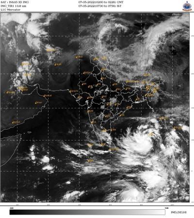
A low pressure area (LPA) that has formed over the South Andaman Sea and the adjoining southeast Bay of Bay Bengal is likely to intensify into a cyclonic storm by Sunday evening, the India Meteorological Department (IMD) said on Saturday.
The LPA lies as a Well-Marked Low Pressure Area (WM LPA) as of Saturday morning.
The IMD said the associated cyclonic circulation extends upto mid Tropospheric levels.
"It is very likely to move northwestwards, intensify into a depression over southeast Bay of Bengal during the next 12 hours and further into a cyclonic storm over east-central Bay of Bengal by Sunday evening," R.K. Jenamani, a senior IMD scientist, said.
It is very likely to continue to move northwestwards and reach west-central and the adjoining north-west Bay of Bengal off north Andhra Pradesh-Odisha coasts by May 10, he said, adding: "By this evening, we will know if it will cross the coast or not."

While the Andaman and Nicobar Islands are experiencing thunderstorms and heavy rainfall since the last two days, under the influence of the WM LPA, scattered to fairly widespread light/moderate rainfall is very likely over Arunachal Pradesh, Assam, Meghalaya, Nagaland, Manipur, Mizoram, Tripura for the next five days with isolated thunderstorm/ lightning over Assam and Meghalaya till Sunday.
The IMD has also forecast squally wind speed reaching 40-50 kmph gusting to 60 kmph very likely to prevail over South Andaman Sea and the adjoining southeast Bay of Bengal and Andaman and Nicobar Islands for next three days and warned fishermen not to venture into waters that are likely to be rough to very rough.
![[Representational Image] Vardah cyclone in Andaman and Nicobar island](https://data1.ibtimes.co.in/en/full/629426/vardah-cyclone-andaman-nicobar-island.jpg?h=450&l=90&t=65)
From the perspective of better disaster management till Sunday, the Andaman and Nicobar Islands administration has been asked to completely suspend fishing and tourism activities and for communities, the warnings have asked people to avoid going to areas that face the water logging problems often.


