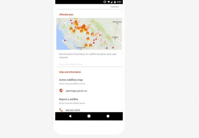
Search engine giant Google has introduced a much-needed SOS Alerts feature in its Maps and Search applications to offer real-time critical information to users on natural disasters nearby.
The company has joined hands with renowned humanitarian rescue organisations and government agencies which are on the front lines of relief efforts, including the Red Cross, the Federal Emergency Management Agency, the Philippine Atmospheric, Geophysical and Astronomical Services Administration, among many others to develop the SOS Alerts feature.
Also read: Flash Player end-of-life details revealed; Adobe passes the baton to HTML5, WebGL and WebAssembly
"In times of crisis, access to timely, actionable information is crucial. Working alongside trained responders and volunteers on the ground, technology plays a vital role in providing information to help keep you and loved ones safe and informed. SOS alerts is a new set of features in Google Search and Maps to help you quickly understand what's going on and decide what to do during a crisis," Yossi Matias, vice president, Engineering, Google said in statement.
How Google SOS Alerts work?
To make things clear, Google's SOS Alert feature is very different from Facebook's Safety Check feature, wherein the latter allows the only user to declare he/she is safe in the affected area. Whereas the former, in addition to crisis alert report option for users, also offers emergency contact details so that users can take immediate measures to survive the calamity.
During a crisis, user will see an SOS Alert at the top of search results when searching for the incident or location. They'll also see maps, top stories and —when available— authoritative local information such as emergency phone numbers, websites, and translations of useful phrases.
Furthermore, Google will automatically alert the users of the disaster in his/her location or nearby affected places, provided they have granted location.

Besides the SOS Alerts, the company also offers Google Person Finder, Google Crisis Map and Google Public Alerts features in the Google Search.
In Google Maps, users will get specific icon on the map and a tappable card with more information about the crisis, such as helpful phone numbers and websites. The map will also include real-time updates, like road closures and traffic and transit updates.
Follow us @IBTimesIN_Tech on Twitter for latest updates on Google products.


