Trekking around meadows and mountains of Pir Panjaal has been my passion for the last 15 years. Almost every summer I along with my friends trek to different places located on the foothills of Pir Panjaal especially around Budgam district.
During the last four months, I hiked several times to explore the mountains, meadows and alpine lakes that originate from different glaciers of Pir Panjaal in my district (Budgam). We undertook our first trek of this season around June 25th to 28th and then we again trekked the same area around July 11 to 13.

We went to a different location on 14th August for 3 days and recently we trekked for a full day around Yusmarg meadow, 42 km from Srinagar. In our June trek, we hiked up to Nawkan Shankar Bulbul area which is the place where the Doodh Ganga river originates.
Similarly, in July we explored the origin of another river Shali Ganga and in August we went to see three alpine lakes called Trusar located at an altitude of 4200 meters.
Pir Panjaal mountain range
The Pir Panjaal mountain range consists of a group of mountains in the Lesser Himalayan region which stretches from Muree in Pakistan in East -Southeast (ESE) to Rohtang Pass in Himachal Pradesh West –North West (WNW). Near the bank of the Sutlej River, it gets dissociated from the Himalayas and forms a divide between

There are several traditional passes in this mountainous range called Galee's. Pir ki Galee is a famous pass that connects the Kashmir valley with Poonch and Rajouri via Shopian. The Banihal pass (Galee) connects the Kashmir valley with Jammu.
Some other major passes in Pir Panjaal are Sinthan pass that connects Anantnag with Kishtwar, Haji Pir Pass in Poonch sector. There are several smaller passes as well like Noorpur Galee, Chor Galee and Choti Galee. Noorpur Galee connects Budgam district with Poonch through Loran. To reach Noorpor Galee it takes almost 6 to 7 hrs to reach there via Tosamaidan or Doodh Patri in Budgam (on foot).

From Kashmir valley, this mountainous range crosses through districts of Baramulla, Budgam, Pulwama, Shopian and Kulgam districts. From the other side, we have Poonch, Rajouri, Reasi, Ramban, Doda and Kishtwar districts located under the foothills of Pir Panjaal. Pir Panjal is also called Pīr Pantsāl in Kashmiri. In Hindu scriptures, this is referred to as Panchaladeva.
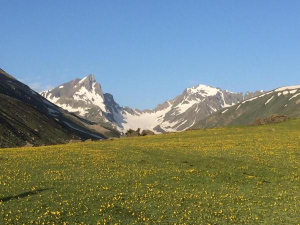
Deo Tibba (6,001Metres )and Indrassan (6,221 Meters ) are two important peaks at the eastern end of the Pir Panjaal mountain range. From the Western side, we have Tatakoti peak (4725 Meters) located between Budgam and Poonch districts in J&K. Famous hill stations like Gulmarg, Doodh Pathri and Yusmarg in Kashmir are located near the foothills of Pir Panjaal.
Summer Trek

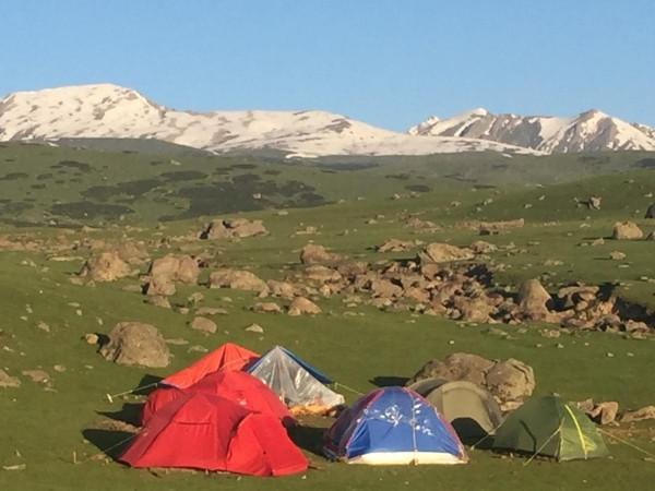
During our first trek this summer we set up our basecamp in an upland pasture inhabited by nomadic Chopans of Kashmir. Chopan is the surname of Kashmiri shepherds, locally known as Pohol. We left from Doodh Pathri around 8:45 am on June 25th 2020 and within 3 hours we were at a meadow called Corag by local shepherds.
Doodh Pathri is a tourist spot in central Kashmir's Budgam district. It is 44 kilometres away from Srinagar and is located at an altitude of 2730 meters. From Dood Pathri one has to trek 1 km to reach Corag with a zigzag and arduous track which takes at least 3 hrs. Corag is located at a height of approximately 3500 meters just adjacent to Danderan meadow.

By 1 pm we pitched our tents and within no time it started raining heavily for 2 hours. In the evening just before sunset while I was walking on the moist grass, I met a Shepherd namely Aziz Chopan who hails from Jabbad Branwar of Chadoora tehsil in Budgam. I had a long chat with Aziz. He told me about the problems and challenges the Chopan community was facing.
In fact, I was already aware of some of these problems as I have been quite often visiting highland pastures in summers. There were some issues about which I was not familiar. I have already written a detailed piece on Chopans in a local English daily some time back
Life of Chopans
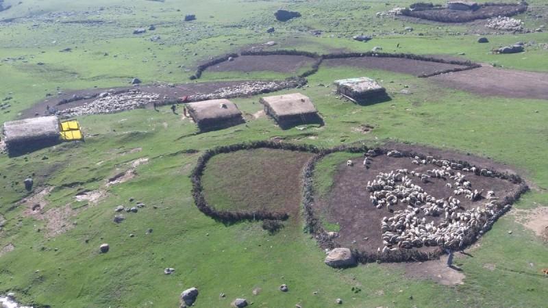
The Shepherds (Chopans) live in a dark, dingy mud house supported by some logs in the meadows and pasturelands of Pir Panjaal. These mud huts are called Pahel Kotha's in Kashmiri. Every Chopan family has an identified Pastureland which is registered with the Revenue Department. These pasturelands also called Bahak in Kashmiri are like a treasure for the shepherds as they live in these Bahak's for at least 3 months from June to August every year. Some of the important pasturelands (Bahak's ) in Pir Panjaal meadows in district Budgam are Diskhal, Dan Deran, Corag, Ayud , Zande Qabar, Lidder Madh, Ashtar , Tosamaidan etc..
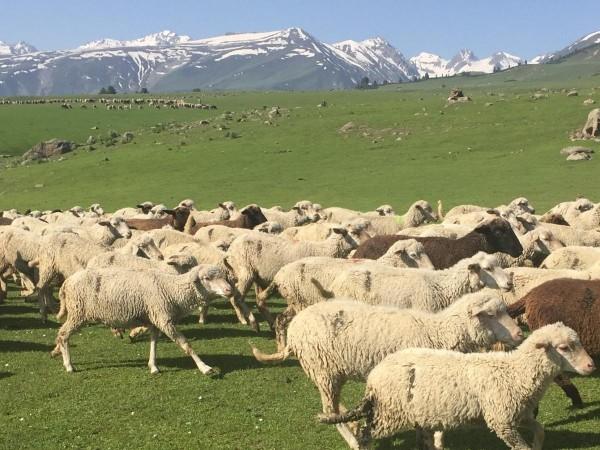
Shepherds own handful of sheep. Most of the sheep they carry belong to farmers who pay them Rs 300 to Rs 350 per sheep for a season. The season for Chopans begins around April and ends by October (7 months max). For two to three months Chopans use local grasslands around their villages to feed the sheep and finally they start moving towards forests and their final abode is their Bahak or Pastureland. Bakerwals from Rajouri and Poonch also have their designated Bahaks in Kashmir and some have Bahak's registered in Pir Panjaal meadows or as far as Tulail Gurez or Drass area as well in Ladakh.

Doodh Ganga
Pir Panjaal is the source of several rivers in Kashmir and Jammu region as well. In District Budgam alone three major rivers Doodh Ganga, Shali Ganga and Sukh Nag originate from glaciers of Pir Panjaal. Similarly, Nallah Vishaw in Kulgam and Poonch river also originates from Pir Panjaal's alpine lakes and glaciers. During our June 25th -28th trek this year we went up to Navkan area which is the source of Doodh Ganga located near Shankar Bul Bul peak. Doodh Ganga is also called Tchatch Kull or Chaz Kull in Kashmiri. The small valley where Doodh Ganga crosses in the Pir Panjaal mountains is called Tchatch kani Naad.
Tchtch Kane means light coloured or even white or greyish stones. One can see white and greyish mountains ridges and rocks in the valley of Tchatch kani naad and I believe that is how Doodh Ganga got its name Tchatch Kull (Light or White coloured river) in view of its greyish –white colour water. Doodh Ganga which means Milky River is the urdu or hindi translation of Chtch Kull.
From Corag meadow (basecamp) to Navkan it took us 3 hrs to reach there and on the way there were beautiful flowers (yellow , blue and purple) on hundreds of acres of grasslands. That was so charming and refreshing I will never forget. After crossing Corag meadows, one has to get down a mountain ridge called Breg Labb.
We then come down the Breg Labb we reach the Doodh Ganga valley (Tchach kani naad) and from here Navkan is located around 45 mins walk. Navkan is a small meadow where Doodh Ganga comes down in a zigzag direction.

Usually, we see Doodh Ganga flowing with high speed in upper reaches but here at Navkan it is calm and quiet and flows downwards quietly through a green velvet-like meadow. It is such a beautiful and secluded place that worshipping here has altogether a different meaning. We left back to our basecamp after spending an hour or so at Navkan.
Trekking around Pir Panjaal mountains in Budgam is very safe and I would appeal to more and more people to trek this area. Trekkers from Jammu can come and enjoy the beauty of these meadows via Poonch. They can trek from upper Loran and enter these meadows via Noorpur gali. Best time to trek these areas is between 1st July to August end.
(About the author: Dr Raja Muzaffar Bhat is Srinagar based RTI activist and columnist. He is an Acumen fellow as well who travels rigorously in the mountains of Pir Panjaal.)


