The latest storm brewing in the Northwestern Pacific Ocean has been analysed by two NASA satellites.
Also Read: Can geckos help scientists clear space debris?
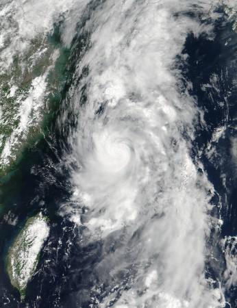
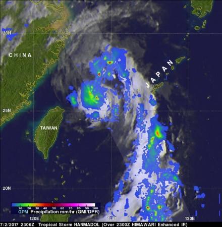
The outside of the Nanmadol storm was examined by NASA-NOAA's Suomi NPP satellite when the winds peaked and a view of the storm's inside was captured by the GPM Core satellite which showed rainfall.
Before consolidating into the fifth depression of the Northwestern Pacific Ocean's hurricane season, Nanmadol was a low-pressure system designated as System 99W. The low-pressure area burgeoned and was renamed Nanmadol on July 2, a NASA statement revealed.
The name comes from an archaeological site adjacent to the eastern shore of the island of Pohnpei, one of the four states in the Federated States of Micronesia. The word means "spaces between" and is a reference to the canals that run through the ruins.

On July 2 2017, at 7:36 pm EDT (5:06 am IST), Global Precipitation Measurement Mission core observatory satellite (GPM) flew above Nanmadol. The tropical storm is located at the northeast of Taiwan which had maximum winds estimated at 45 knots which is equal to 51.8 mph (83.3kph).
The GPM Core Observatory carries the first space-borne Ku/Ka-band Dual-frequency Precipitation Radar (DPR) and a multi-channel GPM Microwave Imager (GMI). Rainfall within Nanamadol was obtained from data accumulated by GPM's GMI and DPR instruments. The data indicated that rain was falling at a rate which was greater than 184 mm (7.2 inches) per hour in the powerful storms of northeast.
At NASA's Goddard Space Flight Center in Greenbelt, Maryland GPM's Radar (DPR Ku band) enabled a 3-D examination of the storm Nanmadol's precipitation anatomy. The data revealed that an eye-like structure was present at the centre of the circulation of this intensifying tropical storm. DPR found that storm top heights near the centre of circulation were reaching altitudes of over 14.4 km (8.9 miles). The tallest storms were seen by GPM in a large feeder band to the south-east of the storm's centre where storm top heights were reaching altitudes of over 16.4 km (10.2 miles).
At 1:12 am EDT (10:42 pm IST) on July 3, the Visible Infrared Imaging Radiometer Suite (VIIRS) instrument aboard NASA-NOAA's Suomi NPP satellite provided a visible-light image of tropical storm Nanmadol. The VIIRS imagery showed a tightly wound tropical storm, with bands of thunderstorms wrapping into the low-level centre from the north-west and south-east. Infrared imagery showed that Nanmadol had briefly developed a pinhole eye.


!['Had denied Housefull franchise as they wanted me to wear a bikini': Tia Bajpai on turning down bold scripts [Exclusive]](https://data1.ibtimes.co.in/en/full/806605/had-denied-housefull-franchise-they-wanted-me-wear-bikini-tia-bajpai-turning-down-bold.png?w=220&h=138)


