While a massive multinational search operation for the suspicious debris of MH370 resumes in the Southern Indian Ocean, the fact that the search is taking place over one of the harshest and isolated points on the planet, is raising fear and panic.
China's state-owned Xinhua News Agency said that more Chinese vessels are being sent to the Southern Ocean in aid to the Australian-led efforts to find the Malaysia Airlines Boeing 777, which vanished out of civilian radar on 8 March with 239 people on board.
The efforts to locate the possible debris of MH370 are taking place over an expanse of deep sea so turbulent and treacherous, which is known to sailors as the "Roaring Forties."
The Roaring Forties are strong westerly winds found in the Southern Hemisphere, generally between the latitudes of 40 and 50 degrees. The aggressive and strong west-to-east air currents are said to be caused by air being pushed from the Equator towards the South Pole and also due to Earth's rotation. More importantly, there are few landmasses in the area to block the winds.
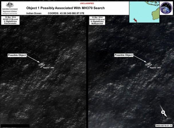
Australia announced on Wednesday that the satellite images may have shown two objects that could be pieces of the missing plane floating in the Indian Ocean more than 1,000 miles off the coast of Pert, Australia.
Four search planes rushed to the area overnight in an attempt to locate the objects for a closer look, but they returned to base without finding the parts seen in the images. Several ships are also headed towards the area to scan for any clues for MH370.
The massive winds that cut across the open expanse of sea are not slowed down or cooled by any land mass, allowing gusts that can create waves of up to 20 feet, Australia's ABC Science said.
Experts fear that the parts seen in the images could never be found, partly because of the aggressive Roaring Forties. The winds and the turbulent waves in the waters would have displaced the objects, possibly hundreds of miles away from where the images appeared to be in the satellite.
More importantly, the average depth of the water is more than 14,000 feet and the currents are strong. If the parts seen in the satellite sank, it would have sunk to an untraceable depth.


