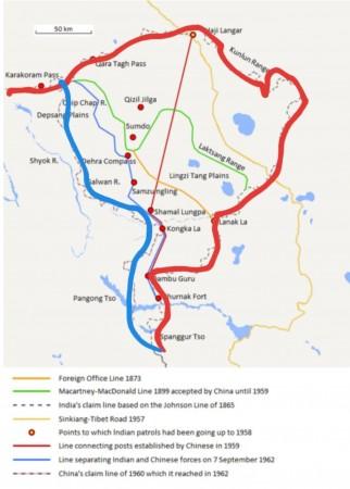
Hardening its stand on the current border standoff, China has again pushed for its old claim line in Ladakh, which was defined in 1959. The Chinese muscle-flexing continued as it also said that it does not recognize the Union Territory of Ladakh and is opposed to the construction of Indian infrastructure there. The Indian side was quick to rebut the Chinese claim lines which it has since 1959.
In a sharp note, New Delhi responded, that it t has "never accepted the so-called unilaterally defined 1959 Line of Actual Control", and that it is "untenable". Indian further contested that the insistence of the Chinese side that there is only one LAC is "contrary to the solemn commitments made by China." What is this is sudden pop up of the 1959 claim by the Chinese side? Let's find out.

China's 1959 LAC claim line
The Chinese claim line of 1959 originated with the 1914 Simla Convention, which demarcated McMahon Line that separated Tibet from India. The Chinese have never raised any formal opposition to the McMahon Line since the signing of the Simla Convention on 3 July 1914 until January 1959. It was first contested in a letter written by Zhou Enlai, the first premier and head of government of the People's Republic of China to then PM Nehru.

China claimed that since the McMohan line was demarcated by the British who have illegally occupied Tibet, the line can't be considered 'legal'. In response, China gave some newer maps to India claiming the boundary line to be located on the western side of the McMohan line. This claim line contested the majority of Aksai Chin to be a Chinese part which the PLA later captured illegally in the 1962 India-China war.
British journalist and scholar, Neville Maxwell has also highlighted the Chinese tactics in his book, India's China War. He writes, "In the eastern sector, Chinese maps continued to ignore the McMahon Line and showed the Sino-Indian boundary along the foot of the hills… In the western sector, Chinese maps showed the boundary lying south-east from the Karakoram Pass to the Changchenmo River Valley." Pandit Nehru rejected this line and ordered the Indian troops to patrol the forward areas. More than 60 years later, China reasserted its claims.


