![[Representational Image] India's own desi-GPS NavIC made by ISRO to go live next year In Picture: ISRO's PSLV-C34 IRNSS, NavIC, GPS, GLONASS, ISRO's PSLV-C34,](https://data1.ibtimes.co.in/en/full/634390/isros-pslv-c34-launches-20-satellites-one-go.jpg?h=450&l=50&t=40)
Indian Space Research Organisation (ISRO) will commence operation of Indian Regional Navigational Satellite System (IRNSS), also known as NavIC service in early 2018, which would make India join the elite group of handful of countries, to have its own GPS (Global Positioning System).
Now, ISRO is currently conducting tests on IRNSS for accuracy and if all things go as planned, it will be made available for public use in early 2018, Tapan Misra, the director of Ahmedabad-based Space Application Centre (SAC) said to The Times of India.
Also read: ISRO and NASA to jointly launch NISAR, the biggest and most expensive earth imaging satellite
IRNSS will provide two types of services, namely, Standard Positioning Service (SPS) which is provided to all the users and Restricted Service (RS), which is an encrypted service provided only to the authorised users.

ISRO spent Rs. 1,420 crores on building and setting up seven IRNSS aka NavIC satellites in the orbit. It is said to be more precise than US's GPS. The former is capable of providing position accuracy of 5 metre, whereas the latter has a position accuracy of 20-30 metre.
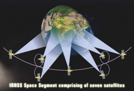
On April 16, ISRO launched the IRNSS 1G, seventh and the final IRNSS series in to the orbit, thus completing the "Space Segment." Out of the seven satellites, three have been positioned in geostationary orbit, while the other four are placed in "inclined geosynchronous orbit."
Other notable NavIC trivia you should to know:
- NavIC means 'Navigation with Indian Constellation' and in Hindi, it translates to 'sailor' or 'navigator
- NavIC provides meticulous location and timing (via highly accurate Rubidium atomic clock ) details as the Standard Positioning Service (SPS) to the users in India
- NavIC's Space Segment will send the location and time information to a chain of 'Ground Segments' located at 21 different locations in India. The ISRO Navigation Centre in Karnataka's Byalalu area will operate as the head of all other stations.
- Since NavIC has seven satellites, its reach is limited to India and surrounding regions extending up to 1500 km from its boundary. Whereas, US' GPS has 24 satellites that cover whole of Earth and also beyond (a few thousand miles in to the orbit). But, the former is said to be more accurate than the latter.
- Besides terrestrial, aerial and marine navigation, NavIC will also assist in disaster management, integration of mobiles vehicle tracking and fleet management, among other useful services.


