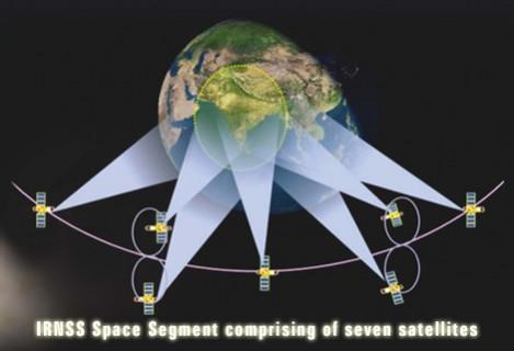
A US decision to designate India's homegrown satellite navigation system Navigation with Indian Constellation (NavIC) as an "allied" system vis-à-vis Global Positioning System (GPS) gives a boost to the Indo-US strategic ties. The decision of the US Congress means that the Indian Space Research Organisation's (ISRO) regional navigation system will be treated at par with the European Union's Galileo and Japan's QZSS.
Multi-global navigation system
The conference report of the National Defense Authorization Act (NDAA) 2020, which Congress approved, designates Russia's GLONASS and Chinese Beidou as a "non-allied systems", a media report says. This would mean that the US satellite navigation system of GPS (Global Positioning System) will not co-operate or exchange data with these two satellite navigation systems.
The receiver, it says, would be capable of accessing signals to increase the resilience and capability of military position, navigation, and timing equipment...
NavIC is Indian Space Research Organisation's (ISRO) autonomous regional satellite navigation system that provides real-time positioning and timing services. The conference report goes to the House of Representatives and the Senate for formal approval before it can be sent to the White House for the nod of President Donald Trump for it become law. The designation of India's NavIC as an "allied system" is part of the American effort to develop a prototype programme for a multi-global navigation satellite system.
As per NDAA 2020, the US Air Force secretary will implement a programme to prototype a satellite receiver working across multiple satellite navigation networks. The receiver, it says, would be capable of accessing signals to increase the resilience and capability of military position, navigation, and timing equipment against threats to the US Global Positioning System (GPS). Such a system would deter the likelihood of an attack on the worldwide GPS by reducing the benefits of such an attack, the report says.

Meanwhile, earlier reports said the ISRO was in talks with some chipmakers to integrate mobile phones with NavIC under Prime Minister Narendra Modi's Make in India initiative. Among those being tapped are US-based company Qualcomm and Singapore's Broadcom, a Times of India reports said quoting ISRO Chairman K Sivan.
Seven orbiters
Sivan claimed that the initiative would be a "gamechanger", but revealed the talks were ongoing and nothing was confirmed yet. ISRO's multi-chip module (MCM) that enabled Indian companies to manufacture NavIC-related technology was developed by Taiwan based company SkyTraQ, the report said. NavIC is the result of ISRO's IRNSS or Indian Regional Navigation Satellite System programme. It is a system of seven navigation satellites, three of which are deployed at Geostationary Orbit that is at an altitude of approximately 36,000km. The other satellites are on Geosynchronous orbits. The satellites were deployed by launched from July 2013 to April 2018.


!['Had denied Housefull franchise as they wanted me to wear a bikini': Tia Bajpai on turning down bold scripts [Exclusive]](https://data1.ibtimes.co.in/en/full/806605/had-denied-housefull-franchise-they-wanted-me-wear-bikini-tia-bajpai-turning-down-bold.png?w=220&h=138)


