Drivers in the U.S. have to be extremely careful of traffic violations, but it can be a daunting task to adhere to the varying speed limits in different parts of the country. Over speeding is one of the most common traffic violations, which can fetch up to $2,500 in fines and the nation-wide average speeding ticket is $150. But Google has a way to avoid speeding tickets in the U.S. and let you be a law-abiding citizen of the States.
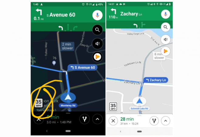
Google Maps is expected to receive a new feature that'll show speed limit markers within the app while using turn-by-turn navigation. The feature isn't entirely new as Google started testing speed limit indicators within the app in San Francisco and Rio de Janeiro back in 2017, but the feature became less reliable when its accuracy was downgraded last year. It looks like Google has no plans to sideline the feature as it is rolling out to more users.
According to Android Police, some users are reporting that Google Maps is showing speed limit markers at the bottom left-hand corner of the app for users in New York City, Los Angeles, and Minnesota. There's no word on whether the feature will be widely rolled out to other users or even to other cities, but it could depend on the area.

Users started seeing the feature without updating their app, which only means Google turned it on from the server side. High population areas are more likely to get the feature as it would gather more reliable data on speed limits.
The entire concept of showing speed limit markers is not new. Waze, another navigation app that's now owned by Google, one-ups Google Maps with this very feature. Since Waze is crowd-sourced, it shows accidents, traffic updates and police checkpoints while you're on road. It will be interesting to see Google Maps get Waze integration to make driving safe in the U.S. and other parts of the world.

This new feature could also help maintain Google Maps' lead ahead of Apple Maps, which recently added turn-by-turn navigation, cabs option in India. Apple is also working on using AR to help users navigate by interacting with the real-world landmarks.


