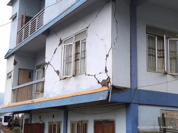
A moderate earthquake measuring 5.5 on the Richter scale, and the second in 12 hours, shook Mizoram, adjoining northeastern states and areas bordering Myanmar on Monday. According to police, there was no immediate report of loss of life. However, many houses, buildings, church and community halls developed cracks due to the tremor.

The IMD official said that the tremor hit eastern Mizoram's Champhai area, adjoining Myanmar, and several parts of the mountainous state at 4.10 a.m. on Monday morning. The epicentre of the quake, that lasted for several seconds, was at 20 km depth.
Mizoram had also experienced earthquakes measuring 5.1 and 5 on the Richter scale on Sunday afternoon (at 4.16 p.m.) and Thursday night respectively. Mizoram police quoting the local people said that the tremors jolted many parts of East Tuipui assembly constituency in Champhai district. "Local people said an aftershock was experienced after half an hour. More than 20 houses, buildings, church and community halls developed cracks after the tremor," a police official said. According to the local people, the Monday morning quake seems to be the strongest one in Mizoram in the recent past.
The IMD official said that a low intensity quake measuring 2.8 on the Richter scale also shook several parts of Nagaland at 12.40 p.m. on Monday afternoon. The epicentre of the quake was at 6.6 km depth. There was no report of any damage or casualty in the Nagaland tremblor.
Seismologists consider the mountainous northeast region as the sixth major earthquake-prone belt in the world. In 1897, a Shillong-epicentre quake measuring 8.2 on the Richter scale had hit the area. In 1950, an earthquake measuring 8.7 on the Richter scale had altered the course of the Brahmaputra river.
(With agency inputs)


!['Had denied Housefull franchise as they wanted me to wear a bikini': Tia Bajpai on turning down bold scripts [Exclusive]](https://data1.ibtimes.co.in/en/full/806605/had-denied-housefull-franchise-they-wanted-me-wear-bikini-tia-bajpai-turning-down-bold.png?w=220&h=138)


