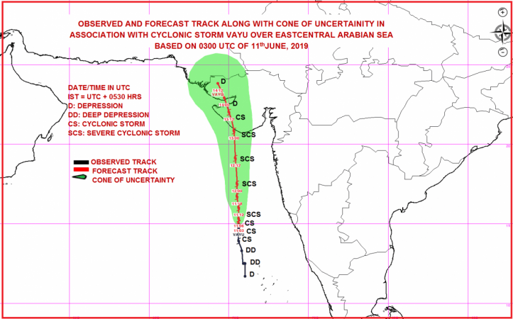
The cyclonic storm Vayu is fast moving northwards over the east-central Arabian Sea and is expected to hit the Gujarat coast between Porbandar and Mahuva in early hours of Thursday, June 13.
The cyclone is expected to intensify into a severe cyclonic storm in the next 12 hours. It will hit the Gujarat coast around Veraval and Diu region, with windspeed going up to go up to 110-120 kmph gusting to 135 kmph.
The deep depression is located off the Lakshadweep coast near Aminidivi.

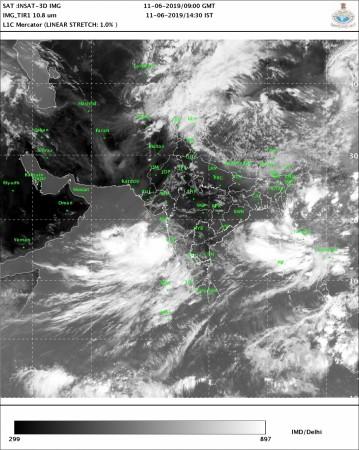
CS ‘VAYU’ about 350 km west-southwest of Goa at 0830 IST. To move nearly northwards & cross Gujarat coast between Porbandar & Mahuva around Veraval & Diu region as a Severe Cyclonic Storm with wind speed 110-120 kmph gusting to 135 kmph during early morning of 13th June 2019. pic.twitter.com/LbjZI6RMwu
— India Met. Dept. (@Indiametdept) June 11, 2019
Fishermen have been advised to not venture into Southeast Arabian Sea, Lakshadweep area, along the Kerala and Karnataka coasts on Tuesday and the east-central Arabian Sea and along the Maharashtra Coast on both Tuesday and Wednesday. Advisory has also been given to not venture into the Northeast Arabian Sea and along Gujarat coast on Wednesday and Thursday.
The schools and colleges in Gujarat have declared a holiday on June 13, anticipating the impact of the cyclone. The Gujarat government is on high alert and has decided to deploy 10 teams of National Disaster Response Force (NDRF) personnel in coastal areas of Saurashtra and Kutch from Tuesday morning.
The government will also put the Army, the Navy and the Coast Guard on alert. Chief Minister Vijay Rupani also reportedly said that people living in the coastal belt would be shifted to safer places.
"We have cancelled leaves of all the employees concerned and asked them to join the duty. After the Cabinet meeting, all the ministers will go to various districts to oversee relief and rescue operations," Rupani told reporters in Gandhi Nagar.

Impact in other states
Due to changes in wind direction because of Vayu, isolated dust storm and thunderstorm activity are also expected in parts of Rajasthan on Tuesday, leading to a marginal drop in temperatures over the region. Scattered dust storm followed by rain and thundershower is expected over many parts of Rajasthan on Wednesday and Thursday.
Mumbai would see good rains and high-velocity winds as the cyclone is expected to cross 250-300 km away, parallel to the Mumbai coast, in the early hours on Wednesday.
In Kerala, Alappuzha recorded 106 mm of rain, Kottayam 92 mm, Kochi 91 mm, Thiruvananthapuram 58 mm, and Kanyakumari 36 mm within a span of 24 hours. Heavy to very heavy rains are expected over coastal Karnataka and Goa in the next 24 hours.
A cause of worry
But while Vayu is expected to not result in widespread destruction, it is a cause of worry because it is likely to halt the northward progression of the monsoon for a few days, by sucking all the moisture from the monsoon winds towards itself.
The arrival of the monsoon has already been delayed, hitting the Kerala coast on June 8 instead of June 1.


