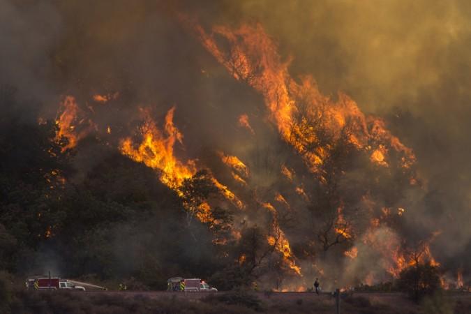
A lightning siege in California has led to massive wildfires, spreading across hundreds and thousands of acres of lands. More than 10,000 lightning strikes have sparked at least 367 new fires, burning across 300,000 acres. Of these fires, 23 are considered to be major ones, Gov. Gavin Newsom said in a press conference Wednesday afternoon.
Despite efforts of containment, it appears to remain out of control. The authorities have ordered evacuation across different parts of the state. Here are county-wise evacuation details and routes.
Hennessey fires have burned 12,500 acres with 0% containment, 15-10 Fire has burned 8,000 acres with 0% containment, Spanish Fire burned 4,000 acres with 0% containment, Markley Fire (5,000 acres), Gamble Fire (13,000 acres), and Morgan Fire (2,000 acres) all with zero percent containment.

Evacuation orders (via ABC7News)
San Mateo County:
- Butano Community Area
- Community of Loma Mar
- Dearborn Park
- Pescadero Creek County Park
- Butano State Park area including Barranca Knolls community
- Butano Creek drainage area
- South Skyline Blvd.
- Russian Ridge Open Space Reserve
- Middleton Tract Area
- Portola Redwoods State Park & Portola Heights Community Area
Evacuation orders in Santa Cruz County:
- Waterman Gap Loop
- Upper 236
- Boulder Creek Golf Course
- Heartwood Hill
- Lodge Road
- Community of Little Basin
- Lower China Grade
- Upper China Grade
- Community of Kings Hwy
- Lower Jamison Creek
- Gallion Heights
- Fallen Leaf Neighborhood
- Foxglove Lane
- Last Chance
- Big Basin State Park
- Las Cumbres (evacuate SOUTH on HWY 236 (Big Basin Hwy) towards Boulder Creek, then access Hwy 9 SOUTH to Santa Cruz)
- Boulder Creek Fire Protection District has received a mandatory evacuation notice. Avoid North on Hwy 235 or Hwy 9. Use South on Hwy 9, or EAST on Bear Creek Road.
- Bonny Doon south of Ice Cream Grade, to include Pine Flat Road South
- Saratoga Toll Road
- San Lorenzo Park
- Riverside Grove-Community of Teilh Drive
- Wildwood Road
- (Zones, BOU38, BOU39, BOU40, BOU41, BOU42, BOU43) via NORTH on HWY 9 to Santa Clara County
Napa County:
- Pope Valley Road from Aetna Springs Road to Chiles Pope Valley Road
- Highway 121 (Monticello Road) from Wooden Valley Road to Vichy Avenue
- Aetna Springs Road from Pope Valley to the dead end
- James Creek Road from Butts Canyon Road to the dead end
- Butts Canyon Road from the Aetna Springs Road to Lake County line
- Wragg Canyon Rd - from Hwy 128 to the end of the road, including Pleasure Cove Resort
- Chiles Pope Valley Road - From Lower Chiles Valley Road to Pope Canyon Road
- All of Berryessa Knoxville Road from the intersection with Highway 128 (southwest of Lake Berryessa) to the intersection with Eastside Road (northeast of the lake)
- Everything immediately west of Lake Berryessa
- Pope Canyon Road from Pope Valley Road to Berryessa Knoxville Road
- From Moskowite Corner to Wooden Valley Road, including the community of Circle Oaks
- Atlas Peak from the Bubbing Well Pet Cemetary at 2462 Atlas Peak Rd. to the dead end
- From Loma Vista Drive and Soda Canyon Road to the dead end
- Snell Valley Road from Butts Canyon Road to Spanish Valley Trail, including the Berryessa estates
- Highway 128 from Lower Chiles Valley Road to Monticello Road
- Highway 128 from Chiles Pope Valley Road to Lower Chiles Valley Road
- Chiles Pope Valley Road from Highway 128 to Lower Chiles Valley Road
- All of Hennessey Ridge Road
Sonoma County:
- North of Austin Creek Recreational Area
- East of The Cedars
- West of end of Mill Creek Road
- South of Stewarts Point-Skaggs Springs Road
- West of West Dry Creek Road and Westside Road
- North of Sweetwater Springs Road and McCray Ridge Road
- East of the East Austin Creek (the actual creek)
Solano County:
- West of Blue Ridge Road to Interstate 505 and north of Cherry Glenn Road Highway 128
- Pleasants Valley Road
- Quail Canyon, Miller Canyon, Mix Canyon and Gates Canyon areas
Evacuation Centres
- Santa Cruz Fairground at 2601 E. Lake Avenue in Watsonville
- Pescadero High School at 360 Butano Cutoff Road in San Mateo County.
Napa County:
- Crosswalk Community Church at 2590 First Street
- For animals, the Napa County Animal Shelter at 942 Hartle Ct.
Solano County:
- The Ulatis Community Center and McBride Community Center
- Large animals can be take to the Solano County Fairgrounds in Vallejo
- Small animals can be dropped off at the Solano County animal shelter on Claybank Road


